Sentier des Charbonnières
This themed loop lets you discover the life of the coalminers. Interpretation panels will help you find information along the way.
Charbonnières... quite a story!
The holm oak, here called "yeuse", is abundant on the warm, shallow limestone of the Mediterranean region.
For many centuries, after its bark had been harvested for the tanning mills that supplied the tanneries, the tree was cut down and its wood used to make charcoal.
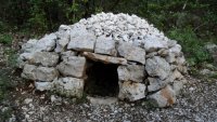
Thanks to its high calorific value, charcoal worked wonders in vegetable gardens and braziers. To make charcoal, the charcoal-maker would erect an elaborate millstone of logs in the middle of a cleared clearing, on the edge of which he would build a small dry-stone hut.
The hut opened onto the charcoal-burning area for better supervision. His art lay in directing the firing, aerating or covering the grindstone: it had to neither catch fire nor burn too quickly to obtain a quality product. The coal then sounded clear. He could deliver it in bags, as far away as Montpellier.
In more recent times, when the demand for charcoal became very great, iron kettles were used for combustion. Many charcoal pits remain in the coppices. Since they were abandoned in the mid-twentieth century, the cabins have been crumbled and more often than not taken over by the vegetation. The soil, however, retains traces of their use in the form of blackened earth on which nothing grows.
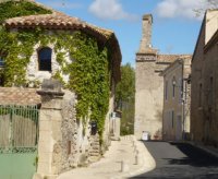
Starting point: Sainte-Croix-de-Quintillargues
From the parking lot, turn left into the village onto the Route d'Assas. Turn right towards the church. Reach the square and turn left into the narrow street, then right at the end.
Continue for 150 m. At the crossroads, turn right for 200 m to a crossroads (calvary). Take the road (chemin du Mas-de-Greffier) on the left for 500 m to leave the village.
In the shade of the pines...
Just after a DFCI track on the left, leave the road for a track on the right, under the pines.
Follow a field to the right and, a few metres further on, leave the main path to take the second path to the left. It winds through a wood and reaches a track, which you take to the right.

Continue straight on for about 200 m...
... then leave the track for a winding path on the left, in the undergrowth. Reach a crossroads. Go left into the Mounié woods. At a further intersection, turn right.

Left or right?
A short variation of the circuit (5.5 km, 2 h) is possible: on the left, pass a charbonnière (theme sign) and continue for 20 m to rejoin the main circuit.
Continue uphill, passing a lapiaz (surface erosion of certain limestone rocks, presenting a series of deep grooves separated by sharp edges), then a charbonnière. Turn left and climb up to an open area.
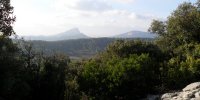
Panoramic view of Pic Saint-Loup.
Access to a viewpoint (50 m): go up to the right (viewpoint over the plain, Pic Saint-Loup, Château de Montferrand, Plateau de l'Hortus), then retrace your steps.
Descend the path (steep descent) for about 100 m. Turn right and wind through the undergrowth to a charcoal kiln (left in its natural state). Descend and find a wider path.
Lime kiln.
Continue downhill (leaving the variant to the left) until you reach a well-marked crossroads. Go straight on, then turn right. Pass a small kiln and turn right to reach a lime kiln.
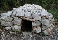
Les charbonnières.
To reach a charcoal kiln (200 m): turn left around the kiln and follow the path to the last charcoal kiln, then retrace your steps.
Below the lime kiln, on the right, continue along the path which winds down through the garrigue to join the track. To the right, follow the same route back to the starting point.

Type : Pedestrian
Start: Sainte-Croix-de-Quintillargues
Length: 5.2 km
Walking time: 2h30
Difference in altitude: 440m

To find out more.

